Chongqing's 8D Architecture
🌀 Chongqing's 8D Architecture
Welcome to the city that broke Google Maps. Chongqing's mountainous terrain has created some of the most mind-bending urban architecture on Earth.
Why "8D City"?
Most cities are flat — you navigate in 2D (left/right, forward/back). Chongqing adds vertical layers: buildings are stacked on hills, roads pass through apartment blocks, and your GPS shows you at street level when you're actually on the 10th floor. YouTubers call it "8D" because dimensions seem to fold in on themselves.
The Famous Spots
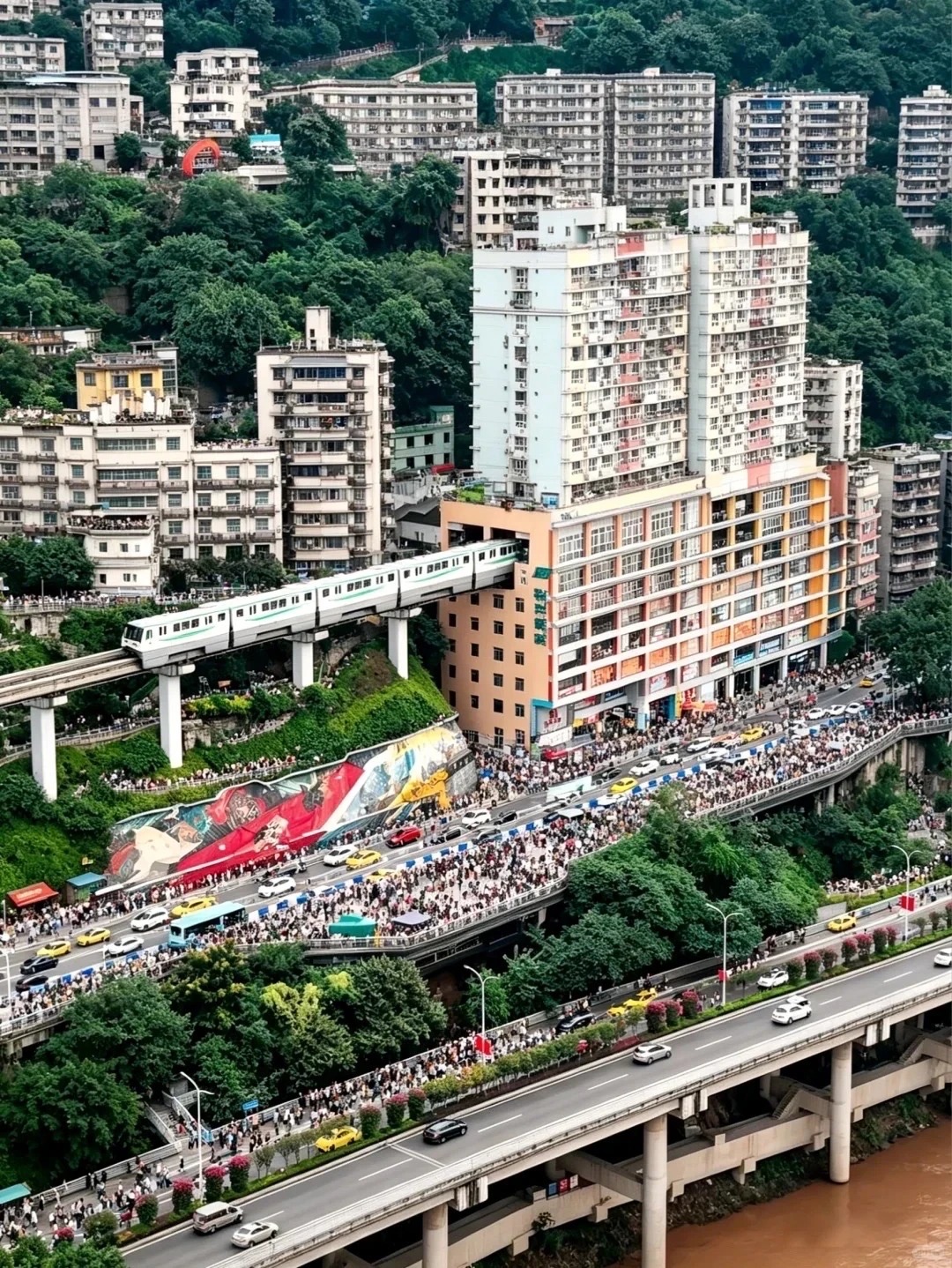
🚇 Liziba Station — Metro Through a Building
The most viral Chongqing video on YouTube.
Line 2 of the Chongqing Metro passes through the 6th to 8th floors of a residential apartment building. The train enters the building, stops at the station inside, and exits the other side.
| Detail | Info |
|---|---|
| Location | Liziba Station (李子坝站), Metro Line 2 |
| Cost | Free to watch from outside, ¥2-5 to ride through |
| Best viewing spot | The observation platform below the building |
How to experience it:
- Stand on the viewing platform below and watch trains enter the building (every 3-5 minutes)
- Ride the metro through the building yourself — you won't notice anything special from inside
- Take a video from the platform — this is one of the most shared China travel clips on social media
🛗 Chaotianmen Escalator — Asia's Longest Outdoor Escalator
An outdoor escalator that climbs a steep hillside:
- 112 meters long, 52.7 meters high
- Connects the river level to the upper city
- ¥2 per ride
- Located near Chaotianmen Dock
🌉 Huangjuewan Overpass — The 5-Layer Interchange
A highway interchange that's 5 stories tall with 8 ramps going in different directions. It became a meme because even GPS gets confused here.
- Best viewed from below (street level) looking up
- Located in the Nan'an district
- Not a tourist attraction per se — just mind-boggling engineering
🏔️ Hongya Cave — The Cliff Building
See our Hongya Cave guide — an 11-story building built into a cliff. The ground floor is on the riverbank, but the top floor exits onto the street at the top of the hill.
🛤️ Yangtze Cable Car
See our Cable Car guide — a public transit cable car crossing the Yangtze River. Originally built because the terrain made bridges too difficult.
Why Is Chongqing Like This?
Chongqing is built on mountains at the confluence of two rivers (the Yangtze and Jialing). The city has almost no flat land, so architects had to get creative:
- Buildings follow the contour of hills
- Roads spiral up mountainsides
- "Ground floor" can mean completely different things in adjacent buildings
- A building might have entrances on 3 different streets at 3 different elevations
- Rivers and mountains cut through the city, requiring bridges, tunnels, and cable cars
Pro Tips
-
Download Amap, not Google Maps — Google Maps is blocked, and even if you have a VPN, it's inaccurate in Chongqing's 3D terrain. Amap handles it better.
-
Liziba Station is a 10-minute stop — don't plan a whole day around it. Watch the trains, take a video, move on.
-
Walk the city — the best way to experience the 8D-ness is on foot. You'll discover staircases between neighborhoods, hidden alleys, and bridges to nowhere.
-
Bring good shoes — Chongqing has more stairs than any city you've ever visited. Your legs will feel it.
-
The 3D-ness is real — your phone's GPS will show you at street level while you're on a pedestrian bridge 10 stories up. This is normal. Trust your eyes, not the map.
FAQ
Why is Chongqing called the 8D city? The mountainous terrain creates a multi-layered city where roads, buildings, and metro lines exist at vastly different elevations. GPS and maps often fail because they can't account for the vertical dimensions. YouTubers coined "8D city" to describe this experience.
Where is the metro that goes through a building? Liziba Station (李子坝站) on Metro Line 2. The train passes through floors 6-8 of a residential building. There's a free observation platform below for photos.
Does Google Maps work in Chongqing? No, Google Maps is blocked in China. Even with a VPN, it's inaccurate for Chongqing's terrain. Use Amap (高德地图) or Baidu Maps instead.
Is Chongqing difficult to navigate? It can be disorienting. Streets at different elevations may have the same name, buildings have entrances on multiple levels, and GPS often shows you at the wrong height. Ask locals for help — they're used to it.
What's the best way to experience Chongqing's 8D architecture? Walk. Take Metro Line 2 from Jiefangbei to Liziba to see the city from above, then walk through the neighborhoods. Every block has something surprising.
Last updated: 2026-06-05 · Written by Bobby, living in Chengdu since 2023